15.07.2025.
13:13
A storm rushes towards Serbia PHOTO/MAP
The Republic Hydrometeorological Institute (RHMZ) announced for Wednesday, July 16, short-term rain or local showers with thunder in the afternoon in Serbia.
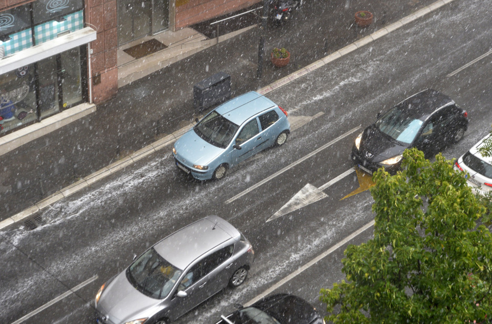
According to the latest forecasts, Vojvodina will be hit first in the evening, with an average amount of 20 to 40 milliliters of rain.
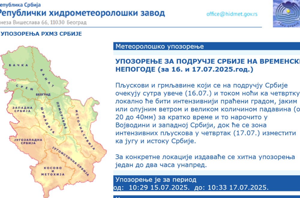
"The showers and thunderstorms expected in Serbia tomorrow evening (July 16) and during the night towards Thursday will be locally more intense, accompanied by hail, strong or stormy winds and large amounts of precipitation (from 20 to 40mm) in a short time, especially in Vojvodina and western Serbia, while the zone of intense showers will move to the south and east of Serbia on Thursday (July 17), warned the Republic Hydrometeorological Institute (RHMZ).
When is the most precipitation expected?
According to meteorologist Ivan Ristić, the most precipitation is expected on the night between Wednesday and Thursday.
Ristić told "Blic" that models are predicting a front that will bring a lot of rain.
"We are expecting a large amount of rain on the night between Wednesday and Thursday. A front is coming, we are not expecting a storm, but precipitation of 20 liters or more per square meter. That will benefit crops and there will be significantly less chance of fires. After the rainy night, on July 17th it will be noticeably cooler, the temperature will drop to around 23-24 degrees, and then we will see an increase in maximum temperatures again," says Ivan Ristić.
Meteorologist Marko Čubrilo also announced the penetration of a cold front between Wednesday and Thursday.
"On Wednesday evening, a cloudy zone will arrive from the northwest, which is linked to a cold front and will bring thunderstorms as well as local weather events, first to the northwest of the region. Over most of the region, it will be noticeably cooler with maximums of 17 to 24 degrees Celsius, still warm in the south until the evening, when it will cool down," said Čubrilo.
Storm is coming from Hungary
According to data from the Vreme and Radar website, a cold front will arrive in Serbia on Wednesday evening, at 8 p.m., passing through Slovenia, Croatia, and continuing down Hungary.
Hydrological warning
The Republic Hydrometeorological Institute (RHMZ) also warned that water levels on the Sava near Sremska Mitrovica and Šabac will be around and slightly below low navigation levels in the coming days.
"On the Kolubara with its tributaries, on the Jadar, on the Mlava, as well as on the upper reaches of the Western and Southern Morava with their tributaries, flows have approached the minimum average monthly values of 95% security (biological minimum)," it was stated on the RHMZ website.
0 Komentari
Možda vas zanima

Rat – dan 1.611: Rusi napali Kijevsku oblast: 10 mrtvih, 100 povređenih; "Namerno smo ih gađali" FOTO/VIDEO
Rat u Ukrajini – 1.611. dan. Moskva je preuzela odgovornost za smrtonosni raketni napad na prezentaciju odbrambene industrije u Kijevskoj oblasti, navodeći da je namerno gađala izložbu na kojoj su bili prikazani dronovi ukrajinske i strane proizvodnje.
23:55
24.7.2026.
2 d

Mali najavio sjajne vesti za penzionere: "Prvo se isplaćuju penzije, a odmah zatim jednokratna pomoć"
Ministar finansija Siniša Mali ukazao je u objavi na svom Instagram nalogu, da su dobro stanje javnih finansija, odgovorna ekonomska politika i rezultati koje godinama ostvaruju, omogućili da ispune još jedno obećanje dato građanima Srbije.
10:41
25.7.2026.
1 d

Kreće veliki projekat u komšiluku: Povezuje se sedam gradova
Pokrenuta je inicijativa za izgradnju novog putnog koridora kroz zapadnu Bosnu, koji bi vremenom mogao postati jedan od najvećih infrastrukturnih projekata u tom delu zemlje.
11:34
26.7.2026.
22 h

Nemački gigant otvara novu fabriku: Stiže novih 900 radnih mesta
Dok brojne industrijske kompanije u Nemačkoj zatvaraju pogone i ukidaju radna mesta, odbrambena industrija nastavlja da širi svoje poslovanje.
17:31
24.7.2026.
2 d

Dva crvena, 10 žutih i ludilo – Partizan protiv Mačve upisao prvu pobedu u SLS VIDEO
Partizan je posle velike borbe savladao Mačvu u Šapcu rezultatom 3:1. Zubairu je doneo vođstvo crno-belima, Vidakov izjednačio, a pobedu su u finišu overili Demba Sek i Šaka Traore.
23:39
26.7.2026.
10 h


Komentari 0
Pogledaj komentare Pošalji komentar