Society 0

01.06.2026.

0:00

Severe weather approaching Serbia: State Hydrometeorological Institute issues alerts

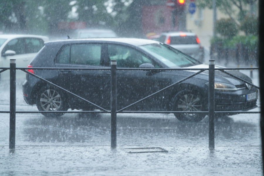
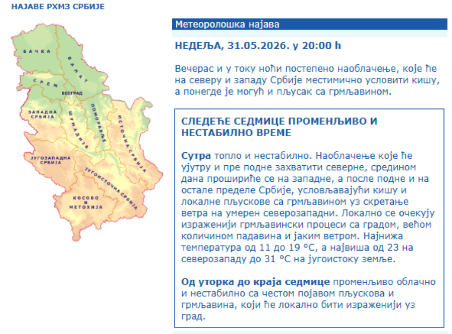
Meteorologist Marko Čubrilo has warned that, starting Monday, Serbia and the wider region can expect a highly unstable and changeable weather pattern, with frequent showers and thunderstorms, the passage of several cold fronts, localized severe weather events.

Izvor: Blic/Teodora Boškovkski, Blic/ Zlatko Čonkaš

Severe weather approaching Serbia: State Hydrometeorological Institute issues alerts
Stipe Majic / AFP / Profimedia

Podeli:

The State Hydrometeorological Institute of Serbia has also issued alerts, particularly for tomorrow, when an orange weather warning will be in effect due to two hazardous phenomena — heavy downpours and thunderstorms. The agency announced that it will issue additional warnings up to two hours before severe weather develops.

A storm accompanied by strong winds and thunderstorms struck parts of eastern Slovenia on Saturday evening, while meteorologists are again warning of the possibility of severe weather tonight, especially in the northeastern part of the country.

In Croatia, specifically in the Zagreb region, an orange warning has been issued due to dangerous weather conditions, including the risk of heavy showers, thunderstorms, and localized hail. This same cold front is expected to move from Slovenia through Croatia toward Serbia, prompting tomorrow’s severe weather warning.

According to forecasts by meteorologist Marko Čubrilo, there are currently no signs of a stabilization in weather conditions or significant warming until at least mid-June. Some days could even bring more severe storms due to the large amount of energy expected to accumulate in the atmosphere.

First instability already today

As Čubrilo notes, Atlantic influence is gradually strengthening over the region, and the first signs of instability are expected to develop over the western parts of the region during the day. Until Monday morning, localized showers and thunderstorms will also be possible in northern areas.

The real weather change arrives on Monday, when a frontal system will move across the region, bringing thunderstorm activity, localized severe weather, and temporarily strong northwesterly winds.


Highest risk of severe weather on Monday

According to current forecasts, the greatest risk of severe weather exists over central parts of Bosnia and Herzegovina, eastern parts of Croatia, and central and eastern regions of Serbia. However, severe storms will also be possible elsewhere across the region.

The passage of the front will bring cooler air, with maximum daytime temperatures ranging from just 17°C in the west to around 27°C in the east of the region.

New cold front brings even greater risk

On Tuesday, conditions will remain partly to mostly cloudy, with localized showers and thunderstorms, primarily in the mountainous areas of Bosnia and Herzegovina, Serbia, and Montenegro. The likelihood of more serious storms will be considerably lower that day, while temperatures will range between 21°C and 28°C.

However, another cold front is expected to arrive on Wednesday, accompanied by the formation of a shallow cyclone over the Adriatic Sea. According to forecasts, the risk of severe weather on Wednesday may be even higher than on Monday.

Meteorologist Marko Čubrilo warns that the atmosphere will contain significantly more energy, creating favorable conditions for the development of powerful thunderstorm systems and more severe weather events. From midday onward, frequent showers and thunderstorms are expected, locally accompanied by strong winds, heavy rainfall, and hail.

No significant warming until mid-June

Following the new cooldown, maximum temperatures on Thursday will generally range between 17°C and 23°C, with occasional showers and thunderstorms continuing across parts of the region.

Severe weather approaching Serbia: State Hydrometeorological Institute issues alerts
FOTO TANJUG/ MILOŠ MILIVOJEVIĆ/ nr

By the end of next week, most meteorologists expect a brief period of more stable weather and a moderate rise in temperatures, with maximum values ranging between 24°C and 29°C.

However, according to medium-range forecasts from the European Centre for Medium-Range Weather Forecasts (ECMWF), an upper-level cyclone could remain over eastern Europe between June 9 and June 15, continuing to influence weather conditions in Serbia and the wider region. This would mean that unstable weather could persist through the first half of June, with no signs of a significant or long-lasting summer warm-up.

RHMZ: Storm warnings to be issued one to two hours in advance

The State Hydrometeorological Institute of Serbia has also issued a warning for showers and thunderstorms expected across Serbia during the first part of next week, from June 1 to June 4, 2026. Locally, storms may be more intense, bringing hail and rainfall exceeding 20 millimeters within a short period.

For specific locations, emergency warnings will be issued one to two hours in advance.

Orange weather alert in effect tomorrow

A yellow weather alert remains in force today due to high temperatures and thunderstorms. However, the greater concern comes tomorrow, when an orange weather alert has been issued for almost all of Serbia—except for the province of Vojvodina, where a yellow alert remains in effect.

The orange alert has been issued because of thunderstorms and heavy rain showers associated with the expected sharp deterioration in weather conditions.

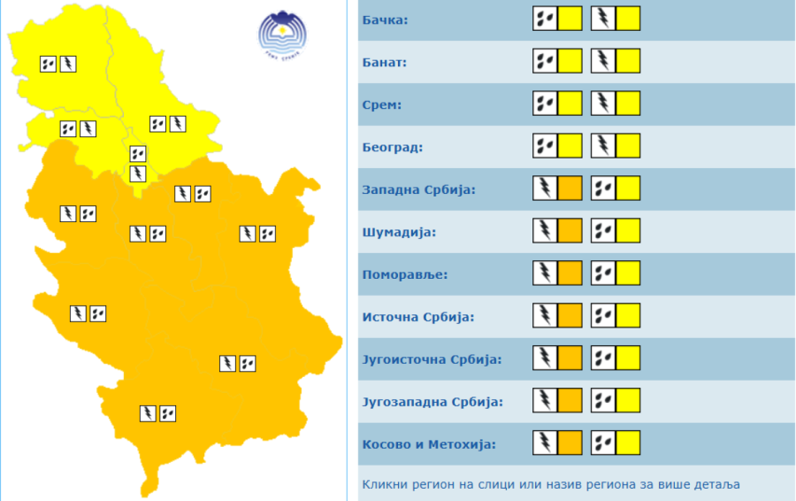
  • Local thunderstorms with hail

    “Risk of lightning strikes, danger to the lives of people and animals, disruptions to the operation of all devices that use electrical power, risk of fires, telecommunications problems, and the possibility of significant damage to movable and immovable property and agriculture, especially when combined with strong winds and intense downpours,” warns the State Hydrometeorological Institute of Serbia.

    Heavy showers or intense rainfall exceeding 10 l/m² within a three-hour period

    “Difficulties in urban areas (particularly problems with stormwater drainage systems and collectors), disruptions to traffic and transportation, and delays to already planned agricultural activities. Damage to movable and immovable property, as well as injuries to people and animals, are also possible,” the RHMZ emphasized.

Severe weather approaching Serbia: State Hydrometeorological Institute issues alerts
Prinstrkin/www.meteoalarm.rs

Unstable weather expected throughout the week

According to forecasts from the State Hydrometeorological Institute of Serbia, Serbia is set for a week of changeable and unstable weather conditions.

“Tomorrow will be warm and unstable. Cloud cover that will affect northern parts of the country during the morning and before noon will spread to western areas by midday and to the rest of Serbia during the afternoon, bringing rain and localized thunderstorms, along with a shift to a moderate northwesterly wind. Locally, more intense thunderstorm activity is expected, accompanied by hail, heavy rainfall, and strong winds,” the RHMZ announced.

Minimum temperatures will range from 11°C to 19°C, while maximum temperatures will vary from 23°C in the northwest to as much as 31°C in the southeast of the country.

From Tuesday through the end of the week, conditions are expected to remain partly to mostly cloudy and unstable, with frequent showers and thunderstorms. In some locations, these storms may become more severe and be accompanied by hail.

 
Severe weather approaching Serbia: State Hydrometeorological Institute issues alerts
Printscreen/RHMZ

Hydrological warning issued

The State Hydrometeorological Institute of Serbia has also issued a hydrological warning for the entire course of the Danube River.

“Over the coming days, water levels along the entire Danube will remain slightly below, or around, the low navigation thresholds,” the agency stated.

Low river levels can affect river traffic and navigation, particularly in sections where shipping channels become shallower than usual. Despite the forecast for periods of rain and thunderstorms, current hydrological conditions indicate that the Danube is expected to remain near low navigational levels in the days ahead.

Beograd
weather_icon

19°C

Vedro nebo

Max temp: 28°C

Min temp: 14°C

Vlažnost: 73%

Vetar: 4 m/s

Pritisak: 1012 mb

Niš
weather_icon

14°C

Vedro nebo

Max temp: 29°C

Min temp: 14°C

Vlažnost: 77%

Vetar: 2 m/s

Pritisak: 1014 mb

Novi Sad
weather_icon

19°C

Mestimično oblačno

Max temp: 23°C

Min temp: 15°C

Vlažnost: 75%

Vetar: 2 m/s

Pritisak: 1012 mb

Kragujevac
weather_icon

15°C

Mestimično oblačno

Max temp: 26°C

Min temp: 15°C

Vlažnost: 88%

Vetar: 2 m/s

Pritisak: 1013 mb

Užice
weather_icon

13°C

Mestimično oblačno

Max temp: 25°C

Min temp: 12°C

Vlažnost: 87%

Vetar: 2 m/s

Pritisak: 1014 mb

Subotica
weather_icon

17°C

Mestimično oblačno

Max temp: 21°C

Min temp: 16°C

Vlažnost: 81%

Vetar: 4 m/s

Pritisak: 1012 mb

0 Komentari

Možda vas zanima

Podeli: