03.11.2025.
10:26
Storm from the Alps approaches Serbia: Meteo-alarm activated; warning issued for 2 hazardous weather phenomena
According to the forecast by the Republic Hydrometeorological Service of Serbia (RHMZ) and the meteorological website "Weather and radar," the first rain clouds and showers are expected to arrive over Serbian territory during the morning.

Showers will first affect the north of the country, followed by the southwest and other regions of Serbia.
According to the RHMZ forecast, in the morning and before noon, northern and western Serbia will experience clouding with rain and local showers with thunderstorms, while in the afternoon and evening, the same conditions will spread to other parts of the country, accompanied by a drop in temperature, i.e., cooling.
Winds will be light to moderate, initially from the south, shifting to the northwest during the day and increasing in strength.
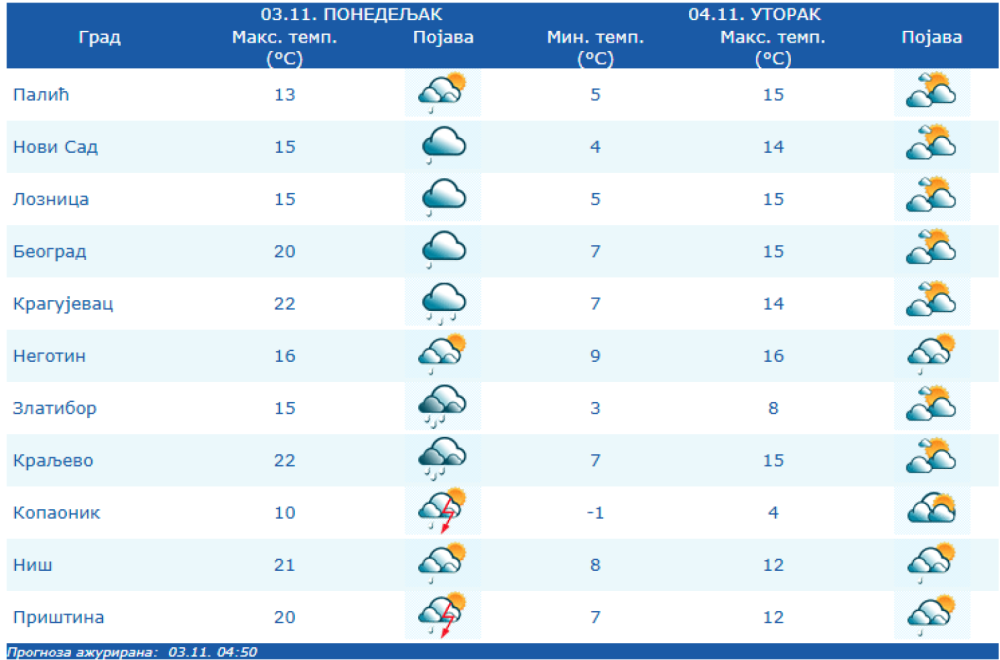
The highest temperatures will range from 13 °C in the northwest to 23 °C in central and southern Serbia.
Rain Cloud Coming to Serbia from the Alps
A strong cloud system and a cold front with precipitation, accompanied by a drop in temperatures, are arriving in Serbia from the Alps and will continue toward our region.
"The rain is expected to stop first in the north and west of the country, later in the afternoon and evening, and during the night in central areas," the RHMZ announces.
Temperatures today
-
Lowest: 4 to 14 °C
-
Highest: 13 °C in the northwest and west, up to 23 °C in central and southern Serbia
On Tuesday (04.11.), precipitation will cease with gradual clearing, except in the east and southeast of Serbia, where partly cloudy conditions will persist.
On Monday, a Complete Turnaround; Midweek Brings Two Hazardous Phenomena
From Wednesday, 5 November, citizens should remain cautious, as two hazardous phenomena are expected – light ground frost and fog.
"During the day it will be mostly sunny with maximum temperatures ranging from 14 to 19 °C. Moderate cloudiness is expected on Friday, 7 November, and over the weekend there may be isolated short-lived rain showers in hilly and mountainous areas," the forecast concludes.
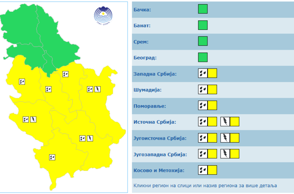
Yellow Weather Alert in Effect
Today, as announced by RHMZ, a yellow weather alert will be in effect across most of Serbia due to two hazardous phenomena – rain and thunderstorms.
How rain will move across Serbia today
According to radar images from the meteorological website Vreme i radar, rain clouds will enter Serbia at 9:00 AM, first reaching the far north of the country.
By noon, the storm is expected to hit Subotica, Loznica, Novi Pazar, and Niš.
At 2:00 PM, rain will reach Belgrade, Novi Sad, Loznica, Užice, and Kragujevac.
By 4:00 PM, radar images show that rain will cover almost all of Vojvodina and continue moving southward.
At 6:00 PM, the rain clouds will be over central Serbia, then move further south hour by hour, so that by 8:00 PM the storm will affect all of central Serbia and the southern regions.
0 Komentari
Možda vas zanima

Deset golova za oproštaj Dešana u ludoj utakmici – Englezima ide bronza, oglasio se Mbape
Fudbaleri Engleske osvojili su treće mesto na Svetskom prvenstvu, pošto su u potpuno ludoj utakmici u Majamiju savladali Francusku rezultatom 6:4 (4:0).
2:36
19.7.2026.
1 d

Apsolutno zasluženo: Španci su prvaci sveta – bruka Argentine; Mesi u suzama; Rodri MVP VIDEO
Španija je novi prvak sveta! Gol Ferana Toresa u 106. minutu doneo je pobedu nad Argentinom (1:0) posle produžetaka, dok je Lionel Mesi u, po svemu sudeći, poslednjem nastupu za reprezentaciju ostao bez odbrane svetske titule
2:00
20.7.2026.
1 d

Srbija održala čas košarke Španiji za finale Evrobasketa!
Košarkaši Srbije plasirali su se u finale Evrobasketa do 20 godina pobedom nad Španijom rezultatom
23:20
18.7.2026.
2 d

"Orlići" vicešampioni Evrope; Džepina u idealnoj petorci – Slovenija prejaka u finalu
Košarkaška reprezentacija Srbije do 20 godina izgubila je u finalu Evropskog prvenstva od Slovenije 84:65 u Ljubljani.
22:00
19.7.2026.
1 d

Iranci oborili moćni MQ-9; Vašington potvrdio: Stradao američki vojnik FOTO/VIDEO
Sukob na Bliskom istoku – 141. dan. Američki vojnik poginuo je na severu Iraka tokom kontrolisanog uništavanja neeksplodirane municije sa iranske samoubilačke bespilotne letelice, saopštio je CENTCOM.
23:40
19.7.2026.
1 d


Komentari 0
Pogledaj komentare Pošalji komentar