

Spring is still on hold
A cold wave from the Arctic is arriving in Europe and Serbia.
Saturday, 03.04.2021.
21:24
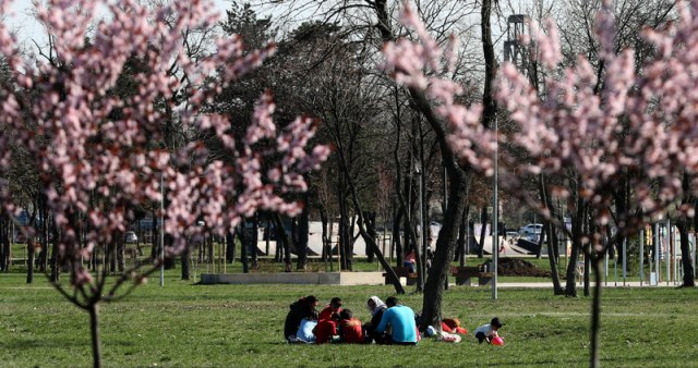
The temperature drop is expected over the weekend; the cool weather front will be followed by rain.
Spring is still on hold
Light morning frost throughout is expected on Sunday and during the next week, locally at a height of 2 m.The lowest temperature will vary from 6 to 9 degrees, maximum from 10 to 18.
Cloudy weather with occasional rain with temperature drop is expected in Belgrade. Wind will be mild and moderate, from the northwest. Lowest temperature expected 8, highest 10 degrees.
On Sunday, mostly cloudy and chilly weather, with occasional rain, snow is expected in the mountains. During the night, in most places, the precipitation will cease with the sky cleared up.
Due to storms expected followed by thunderstorms, a yellow meteorological alarm is in force in the area of Kosovo and Metohija and Southeastern Serbia.
RHSS has also issued a special agrometeorological warning.
Patchy morning frosts are expected (ranging -3 ° C) at a height of 2 meters may lead to damage to flowering species and fruit varieties. The recommendation to agricultural producers is to be on standby and to follow the weather forecast, if needed to apply for adequate flower protection, RHSS stated.
The change of weather is coming to Europe again, and according to experts, we are experiencing a historical cooling. A strong cold wave from the Arctic should reach most of the Continent in the coming days, including the Mediterranean, the Iberian, and Balkan peninsulas, it was reported by the "Severe weather Europe" website.
The cold wave will first hit the United Kingdom and Ireland, and then spread to Central Europe and the Mediterranean at the beginning of the week. Meteorologists predict heavy snowfall in the Alps and the Balkans on Tuesday and warn of the appearance of frost that could endanger flowering vegetation.
Meteorologist Marko Cubrilo posted on his Facebook profile that we are facing a "meteorological extreme" this week.
"This simulation of strong deterioration and cooling will continue on Tuesday afternoon, which could, in addition to the mountains bring snow in other places in the lowlands of the region. "If the current simulations of this model taking place on Tuesday afternoon and at night, continue spreading in this part of the region, including most of the lowlands, we are in for some real winter weather," said Cubrilo.
0 Komentari
Možda vas zanima

"Zbogom bankomati": Uveden novi sistem isplate
Podizanje gotovine za kupovinu postaje sve popularnije među potrošačima u Nemačkoj. Ukupni obim gotovinskih plaćanja prošle godine je porastao 20 odsto na 12,31 milijardu evra.
13:19
18.4.2024.
1 d

Uništeno; Zelenski: Hvala na preciznosti
U ukrajinskom napadu na vojni aerodrom na Krimu u sredu ozbiljno su oštećena četiri lansera raketa, tri radarske stanice i druga oprema, saopštila je danas Ukrajinska vojna obaveštajna agencija.
14:21
18.4.2024.
1 d

Velika eksplozija u Ukrajini VIDEO
U Harkovskoj oblsti na istoku Ukrajine eksplodirao je gasovod, usled čega je izbio požar, saopštila je danas harkovska Oblasna vojna uprava.
22:12
18.4.2024.
1 d

"Mojoj braći na OI želim sve najbolje, ja nisam dovoljno dobar" VIDEO
Košarkaš Dalasa Kajri Irving nije se našao na spisku reprezentacije SAD za predstojeće Olimpijske igre u Parizu.
9:12
19.4.2024.
20 h

Poznata srpska voditeljka pronađena mrtva
Voditeljka Bojana Janković (bivše Nikolić) pronađena je mrtva u jednom stanu u Beogradu.
21:15
19.4.2024.
8 h


Komentari 0