

Storm from Spain moves to the Balkans in the coming days: It is called Philomena
The storm Philomena, which seemed to paralyze Madrid with snow last week, moves across the Mediterranean, already affecting the eastern parts of the Balkans.
Wednesday, 13.01.2021.
11:55

Storm from Spain moves to the Balkans in the coming days: It is called Philomena
The Philomena storm, which left Madrid paralyzed by snow last week, is sweeping across the Mediterranean, has already covered the eastern parts of the Balkans and continues via Serbia towards Greece and Turkey.Due to Philomena, Madrid faced with the heaviest snowfall in decades, while the temperature dropped to a record -36 degrees.
It was the first snow in Madrid in the last 10 years, and the Spain's capital was buried in 50 cm of snow.
The capital of Spain has not experienced so much snow in the last 50 years. At the same time, the monthly amount of rain fell in Gibraltar in just two days.
Meteorologist and columnist of the Croatian portal Index.hr, Dunja Maz, says that in recent years, the rule has been established that hurricanes should be renamed even when they come to Europe as extratropical cyclones, and the countries that are the first to be hit by them give them names.
"But, whether we call that cyclone Philomena or not, the fact is that it is the same system, although in the meantime, passing through the Mediterranean, it has undergone several changes. It has now reached the Ionian and Aegean Seas and continues further east, primarily to Turkey, but also to a part of Greece, it will bring unusual precipitation," says Dunja Maz.
According to her, the anticyclone, which extends from the western part of southern Europe and slowly spreads northwards, will draw polar air as far as the Balkans in the coming days, which is why we will see very low temperatures for the next week.
She adds that these are relatively unusual situations for this part of the world, but reminds that in the last winters there were already strong storms that brought unprecedented snows to the southern parts of Europe, and even to the north of Africa.
According to her, the anticyclone, which extends from the western part of southern Europe and slowly spreads northwards, will draw polar air as far as the Balkans in the coming days, which is why we will see very low temperatures for the next week.
"This situation is the result of the meandering and finally bursting so-called polar vortex in the higher layers of the atmosphere", Dunja Maz says, adding that this extremely cold ice wave is expected in Croatia as well.
It will obviously be felt in Serbia as well, because RHMZ has already issued a warning that icy days are coming to Serbia.
0 Komentari
Možda vas zanima

"Zbogom bankomati": Uveden novi sistem isplate
Podizanje gotovine za kupovinu postaje sve popularnije među potrošačima u Nemačkoj. Ukupni obim gotovinskih plaćanja prošle godine je porastao 20 odsto na 12,31 milijardu evra.
13:19
18.4.2024.
1 d

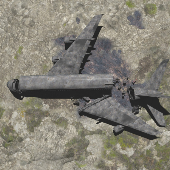
Uništeno; Zelenski: Hvala na preciznosti
U ukrajinskom napadu na vojni aerodrom na Krimu u sredu ozbiljno su oštećena četiri lansera raketa, tri radarske stanice i druga oprema, saopštila je danas Ukrajinska vojna obaveštajna agencija.
14:21
18.4.2024.
1 d

Velika eksplozija u Ukrajini VIDEO
U Harkovskoj oblsti na istoku Ukrajine eksplodirao je gasovod, usled čega je izbio požar, saopštila je danas harkovska Oblasna vojna uprava.
22:12
18.4.2024.
1 d

"Mojoj braći na OI želim sve najbolje, ja nisam dovoljno dobar" VIDEO
Košarkaš Dalasa Kajri Irving nije se našao na spisku reprezentacije SAD za predstojeće Olimpijske igre u Parizu.
9:12
19.4.2024.
17 h

Poznata srpska voditeljka pronađena mrtva
Voditeljka Bojana Janković (bivše Nikolić) pronađena je mrtva u jednom stanu u Beogradu.
21:15
19.4.2024.
5 h


Komentari 0